Inspection of Erosion Control Facilities Using Drones Prepared a draft guideline for inspecting erosion control facilities using drones, contributing to the efficiency of inspection work.
Release:
Update:
NEW

NEEDS
The Need for Safe and Efficient Erosion Control Facility Inspections
Many erosion control facilities (erosion control weirs, stream protection works, etc.) are located in deep valleys or places where there are no access roads. Therefore, in the past, inspectors had to go to the deep valleys by walking and inspecting the facilities manually. Crossing river channels that are usually inaccessible to people and moving between cliffs and structures with height differences are dangerous works that can lead to falling rocks and falls. In addition, due to the poor accessibility of the work site, it is necessary to work for a long time and this results in poor work efficiency. Improving the work efficiency has also become an issue in recent years due to the serious labor shortage issue. At Nippon Koei, we are promoting the use of drones to improve the efficiency and safety of erosion control facility inspections.
SOLUTION
Inspection Technology that Combines Distant and Close-up Shooting
Nippon Koei is developing technologies to utilize the latest technologies of small unmanned aerial vehicles (UAVs), such as their versatile navigation capabilities, onboard camera performance, and autonomous flight functions, in the inspection of erosion control facilities. As a part of this effort, we have prepared a manual, "UAV Inspection Guidelines for Erosion Control Facilities (Draft)" (hereinafter referred to as "Draft UAV Inspection Guidelines"), for inspecting erosion control facilities using UAVs in the Hokuriku Regional Development Bureau's jurisdiction.
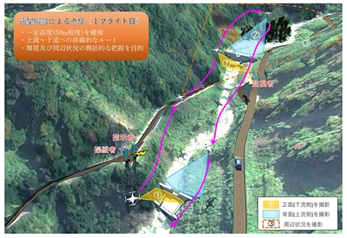
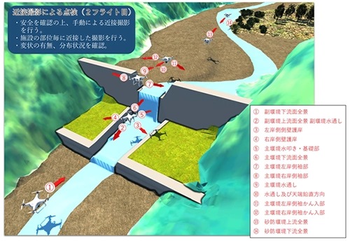
The Draft UAV Inspection Guidelines was prepared with the aim of improving work efficiency and safety, as well as enabling inspections of erosion control facilities to be carried out using UAVs with general-purpose aircraft specifications, without requiring the advanced skills and techniques of inspection engineers or UAV operators. In addition, the Draft UAV Inspection Guidelines is based not only on the inspection by distant photography of UAVs, but also includes the case where UAVs can safely approach a weir, and the case where a more detailed inspection is deemed necessary. If the UAV can safely approach the weir, or if it is judged that a more detailed inspection is necessary, it is proposed that an inspection using close-up photography be conducted as appropriate to improve inspection accuracy. Moreover, the UAV inspection plan must be prepared, and the UAV inspection procedure (draft) includes a preliminary survey for the purpose of setting up safe and efficient flight routes and shooting locations.
POINT
General Soundness Evaluation and Follow-up Inspection
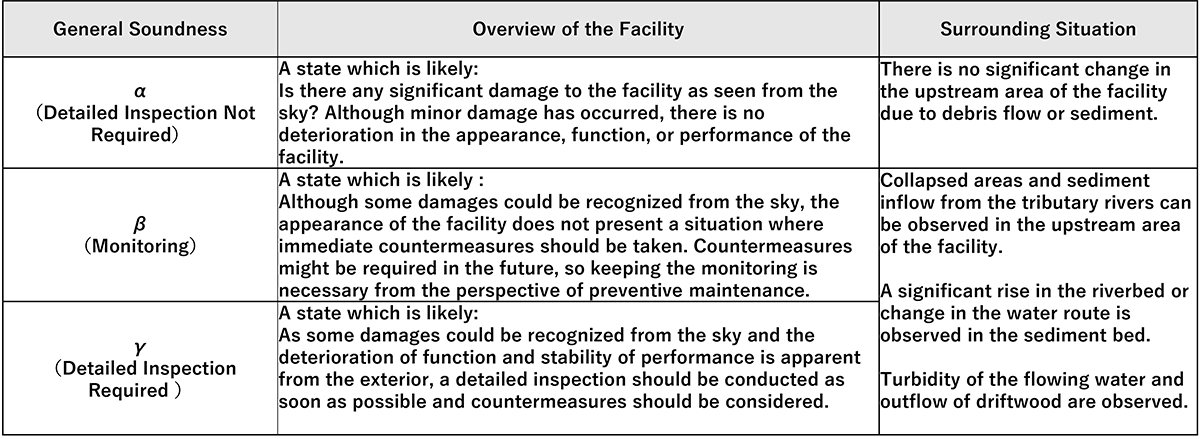
In the inspection of erosion control facilities using UAVs, it is assumed that there may be cases where it is difficult to check the target facility in detail due to obstructions. For this reason, the Draft UAV Inspection Guidelines sets an index called "general soundness" in order to evaluate whether or not there are any problems with the functions and performance of the facility, based on a rough view of the entire facility from a distance. This makes it possible to determine the general soundness of the facility as a tentative assessment by taking photographs from a distance and checking the visible areas. In addition, since the accurate determination of the level of deformation of the target facility is limited by distant photography, a follow-up inspection by manual inspection will be conducted once every five years to follow up on the deformation that cannot be grasped by the UAV inspection, and a system to closely examine the soundness of the facility will be included.

Reference
- Guidelines for Formulation of Life Extension Plan for Erosion Control-Related Facilities (Draft) (March 2020)
https://www.mlit.go.jp/river/shishin_guideline/sabo/sabo_choujumyou_guideline_202003.pdf - Guidelines for Inspection of Erosion Control Facilities by UAV (Draft) (March 2020)
http://www.hrr.mlit.go.jp/river/sabo_challenge/documents/uav_tenkenyouryou.pdf